PR 1_PS Pico Branco and Terra Chã Footpath
 Start: E.R. 111
Finish: Terra Chã
Time: 1h30m
Distance: 2,7 km (+ 2,7 km to return)
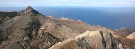
The trail starts at Regional Road E.R.111 and, following the route to the top of Pico Branco we encounter a huge prismatic formation in which the footpath itself was carved. It is called Rocha Quebrada or the Broken Rock. The steepest climb of the walk is made along a heather fence, the climb ending in a rock fissure at Crista do Cabeço. The footpath continues amongst a landscape where cupressus (Cupressus macrocarpa) dominates, until such time as the walker finds a fork leading, on the right to Terra Chã and on the left to Pico Branco, (White Peak), the second highest in Porto Santo.
The name originating from a white rock column & the large quantity of dyer’s weed (urzela) to be found, which was exported from Porto Santo and used in making dyes and other specialities. The Pico Branco and Terra Chã is part of the European network of communitarian interesting places – Natura 2000 Network, Directive Habitats, due to flora and fauna endemic specimens (earthbound shellfish – snails) evident therein.
This is the only area in Porto Santo where the largest amount of naturally occurring indigenous flora was recorded in pristine conditions, mainly due to it being located in rugged areas and on barely accessible slopes, if at all. The indigenous vegetation is mainly comprised of herbs and shrubs.
At Terra Chã a recently restored white stone house, is being utilised in the propogation of endemic plants, with the view to reintroduce them into the environment as well as for purposes of scientific research. Here, two relevant specimens of sea birds can be found, namely the Cory’s Shearwater (Calonectris diomedea borealis) and the Common Tern (Sterna hirundo). At Terra Chã there is a recently restored white stone house, where endemic plants are being propagated for scientific research and for reintroduction in the environment.
Underneath Terra Chã, there is a cave named as Furna dos Homiziados. It was an old hideaway for outlaws and where also, according to the tradition, several people found shelter on their escape from Algerian pirate raids. A local legend recounts how in one of these refuge seeking emergencies, the previously protective roof collapsed, thereby concealing forever all those who were seeking shelter therein.
Various natural sightseeing spots on this trail allow the walker to view a great deal of the Porto Santo island, from Serra de Dentro, Pico do Concelho, Ilhéu de Cima, Pico do Maçarico, Portela, Rocha de Nossa Senhora, the city, part of the beach, Pico Ana Ferreira, Espigão dos Morenos, to Calheta and Ilhéu de Baixo. This trail was constructed with the purpose of being a throughfare for cargo mules, in the time barley was farmed by locals at Terra Chã. Return is made on the same footpath.


